Prior to 1986 surveys, positions were based on maps in scale, ranging from 1:50,000 − 1:250,000, originally from the Danish Geodetic Institution. The Datum definitions for these maps are referred to as "Reykjavík 1900" and "Hjörsey 1955". In the surveys after 1990 (and most probably 1985−86 also) the locations were read directly in (lat,lon) based on WGS84 datum. Later the National Land Survey of Iceland provided a new datum, ISN93, which may differ from the WGS84 by a few decimetres. We consider these bases to be equal because the errors in positions exceed the datum difference by a factor of two or so. Even when using GPS positioning we still have to accept uncertainty of this degree when matching the two time series, positions vs. time and magnetic readings vs. time, taking into account the time lag in the magnetic meter.
It is customary that these different datums have each their own "Default projection", for example, maps based on "Reykjavík 1900" datum are drawn in Lambert Conformal Conic projection with one standard parallel (65° N) and the center point (x,y)=(0,0) at (65°N, 19.022°W), x pointing West at that point and y North.
In the same way, the transformation which is associated with geodetic data recorded in ISN93 base is: Lambert Conformal Conic projection, with two standard parallels (64.25°and 64.75°), central meridian at -19°, centre-point (500,000 m, 500,000 m) set at (65°,-19°), x pointing East and y North. These will be referred to as ISN93 Lambert coordinates. The National Land Survey of Iceland provides a calculator transforming between different datums and projections.
The residual magnetic field is acquired by subtracting the geomagnetic field from the measured field. In its most simple way it may be described here at high latitude as: The vertical component of the rock magnetic field.
All aeromagnetic data collected by the UI Science Institute have been transformed to ISN93 datum (or equally WGS84).
The data are available as:
- a sequence of ISN93 "Latitude, Longitude, residual-field" records, in several survey files as explained below.
- a sequence of ISN93 Lambert coordinates "x,y, residual-field" records in several survey files as explained below. − For file formats see here .
- a Golden Software grid, in ISN93 Lambert coordinates.
- All of Thorbjörn Sigurgeirsson's survey results (1 and 2 below)
were published on nine maps in scale 1:250,000. These maps are available
on request.
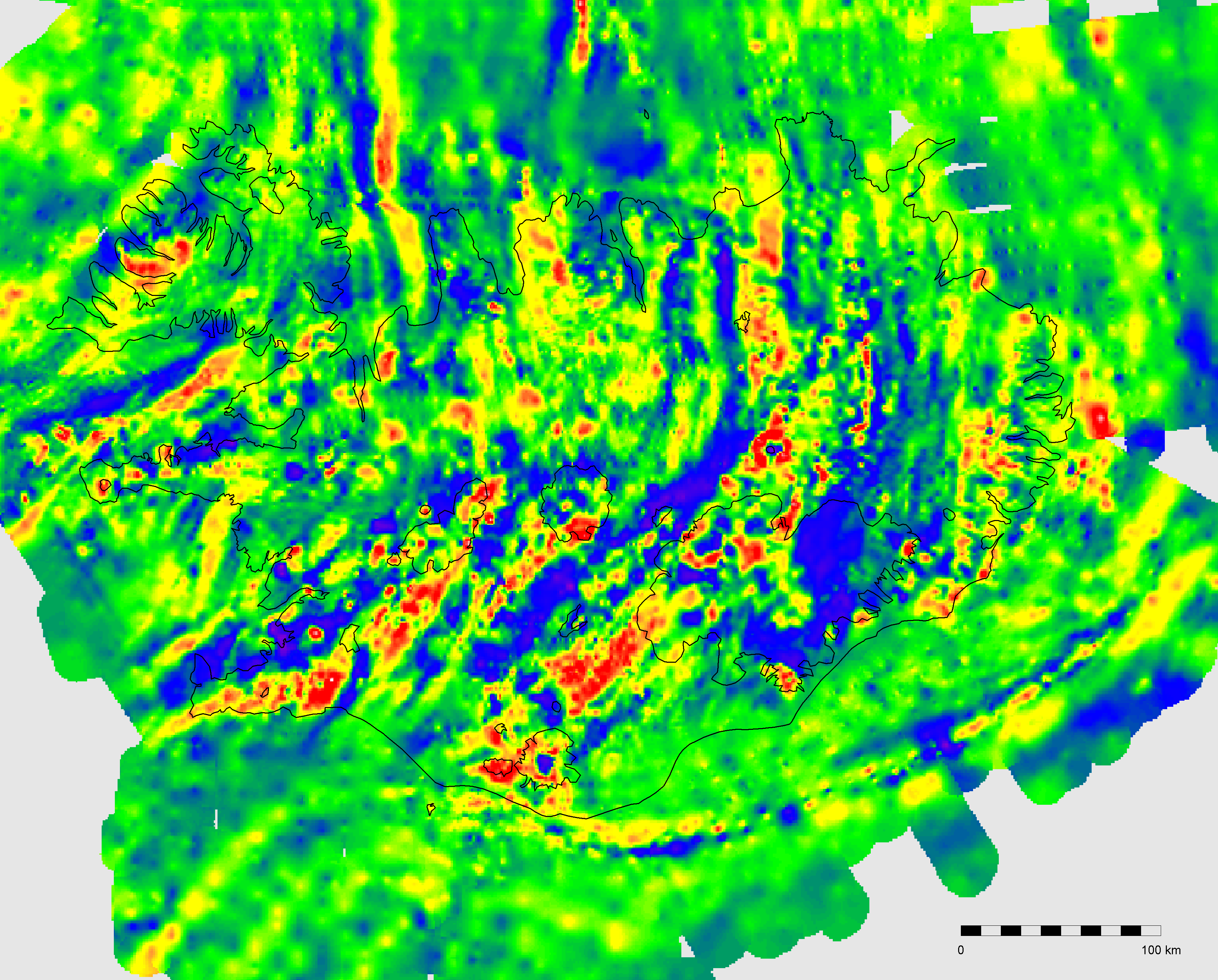 |
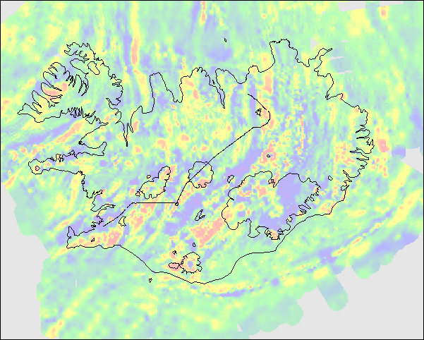
The Residual Geomagnetic Field over and around Iceland. Based
on data from the Science Institute, University of Iceland and other
sources as explained below. (click for a larger picture or download) |
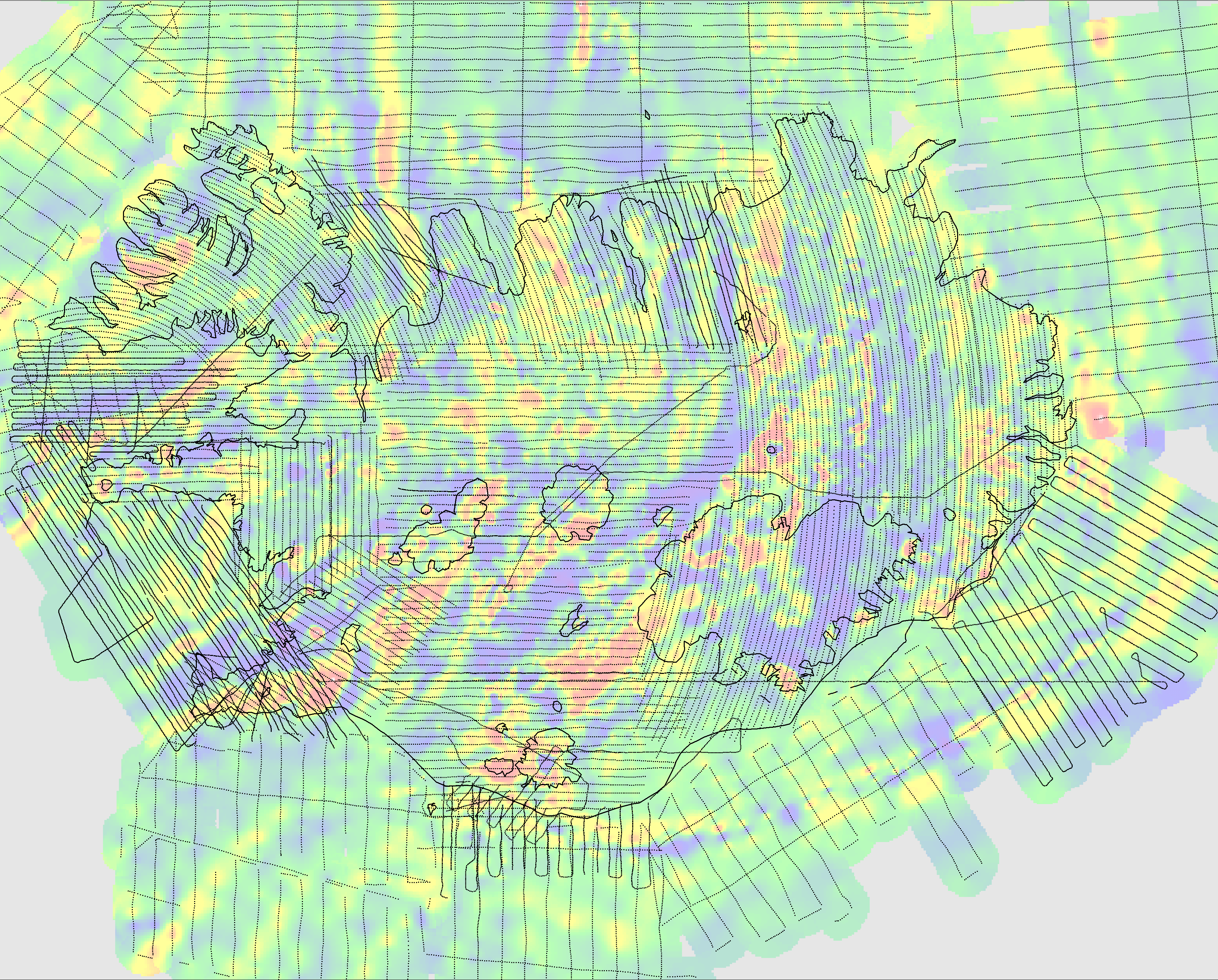 |
Caution should be taken when interpreting the map because the survey
line spacing is much greater than point spacing along lines and
in most cases also larger than grid-node spacing. Here the survey
points are superimposed on the field for reference. (click for a larger picture or download) |
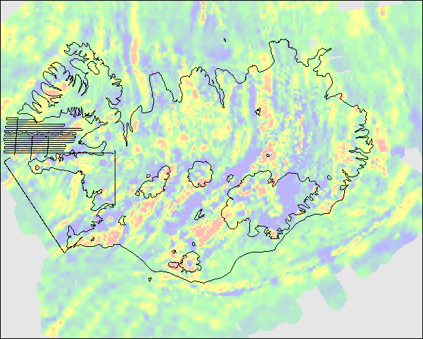
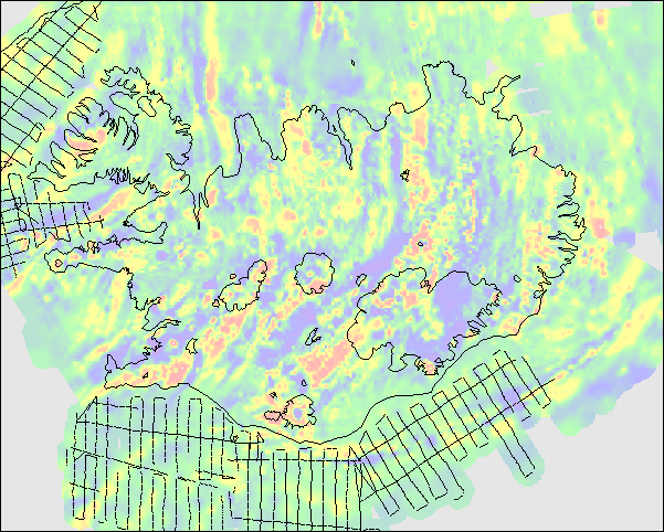
Overview of surveys
| no | Survey/file name |
Year of Survey |
Main Reference |
Spatial parameters / Layout |
| 1 | Thorb_72 | 1968−72 | 1 | Line spacing 4 km visual navigation |
| 2 | Thorb_80 | 1972−80 | 1 | Line spacing 3 km concentric circles |
| 3 | LK_MS_86 | 1985−86 | 1 | Line spacing 3 and 4 km. Loran C |
| 4 | Sudur_90 | 1990 | 3 | Line spacing 5 & 6 km. Loran C |
| 5 | SSA_91 | 1991 | 3 | Line spacing 6 km. GPS and Loran C |
| 6 | Fax_91 | 1991 | 3 | Line spacing 6 km. GPS and Loran C |
| 7 | Fjoll_91 | 1991 | - | GPS |
| 8 | ASA_92 | 1992 | 3 | Line spacing 6 km. GPS |
| 9 | BRFJ_92 | 1992 | 3 | Line spacing 6 km. GPS |
| 10 | Grunn_73 | 1972−73 | 1 | Line spacing 12 km + cross lines. Raydist |
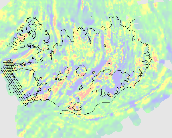
 1. South West Iceland. Thorbjörn Sigurgeirsson 1968−1972. The field was recorded analogically, corrected for temporal variations and manually transferred to maps, along with the "average" or "reference" field, i.e. plotted as the distance from the flight line. Navigation and locations were visual and flight tracks are typically straight lines or line segments 4 km apart, flown over predetermined landmarks. Flight altitude was 900 m over western part of the survey area and 1200 m over the eastern part. In some cases the aircraft had to ascend above the given altitude due to mountains. No effort has been made to correct for different altitudes. The "anomalous field", which we refer to as "residual" field was digitized from the original maps in late 1980s and published with a SIUI report in 1989. Spacing between data points was determined, when digitized, close to 500 m. In the current version, the five files originally making up this survey (Rkj-Myr-Nes-Isb-Iss) are combined in one: Thorb_72 |
 2. North and East Iceland. Thorbjörn Sigurgeirsson 1972−1980. Covering NW-peninsula, Mid-North and entire East Iceland. The field intensity was recorded digitally onboard the plane. Autopilot navigated the plane on arcs of constant distance, in steps of 3 km, from the Loran-C transmitter at Snæfellsnes peninsula. The transverse positioning along these arcs was originally (1972 and perhaps 1974) visual but later also by recording the distance to the transmitter beacon at Rugby, UK. Nominal flight altitude for this survey was 1200 m except over the Vatnajökull glacier, where it was 2100 m. No effort has been made to compensate for this different altitude. The sampling rate resulted in average point spacing around 600 m. Extraction of residual field from the original data was similar to the earlier survey. The original files (VE, MN, AU, SA, VV) are combined into one: Thorb_80. |
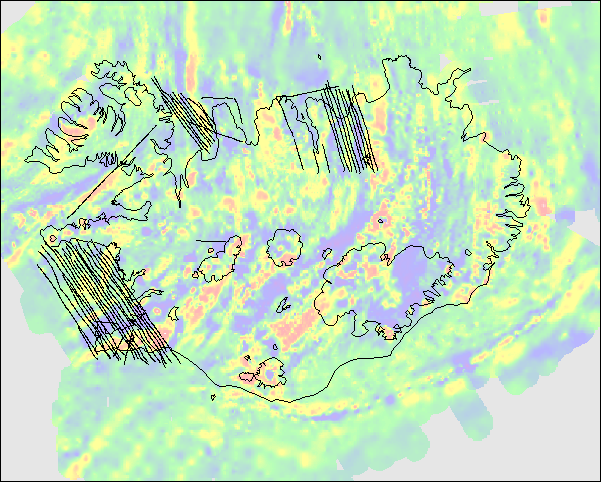 3. Leó Kristjánsson and Marteinn Sverrisson survey in 1985−1986. Covering two bay areas, off west and north Iceland and a gap in Th. Sigurgeirsson's survey in North Iceland. The field was recorded with a Geometrics digital precession magnetometer G-856X recording every 4 seconds which equals to approximately 300 m along the path. Survey lines were laid out to match Th. Sigurgeirsson's line pattern, (spacing 4 km in Faxaflói bay and 3 km elsewhere) and the positions were determined with the aid of Loran-C receiver. Flight altitude 910-980 m, occasionally higher or lower due to cloud conditions. The original files (Hun, Fax, Thi) are combined in LK_MS_86. |
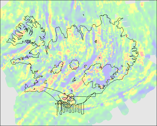 4. South Coast. Leó Kristjánsson and Geirfinnur Jónsson. June 26 and July 2, 1990. The main purpose of this survey was to extend the coverage of Sigurgeirsson's survey 1968-1972 southward and merge it to the marine survey Grunn_73 (see below). There were two survey flights with slightly different parameters. Eighteen offshore N-S lines, spaced 6 km (double the density of Grunn_73 survey) at flight altitude 250 m, sampling interval 5s (eq. to 314 m average spacing) and ten short lines perpendicular to the coast (NE-SW) spaced around 5 km and flown at higher altitude, 900 m, in order to connect these two data sets. Sampling interval 6s, averaging in 384 m spacing along the line. A part of this survey were lines (at higher altitude) flown over the main volcano Katla in Mýrdalsjökull glacier. These have been discussed in a paper in Jökull 2000. The field was recorded with the Geometrics G-856X proton precession magnetometer. The "residual field" was extracted from the original data by subtracting the Sigurgeirsson's "average field" and correcting for secular variations by direct comparison with changes at the Leirvogur Magnetic observatory. The navigation system was Loran-C which had to be corrected with visual observation because of relatively long - and variable - processing time within the unit. The stream of positions was recorded to an onboard computer using an output from the Loran-C, meant for autopilot. The data is kept in one data file, Sudur_90. |
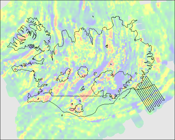 5. Offshore South-South-East. Leó Kristjánsson and Geirfinnur Jónsson. May 6th 1991. To extend the coverage of marine survey from 1972−'73, with special interest on the bathymetric shelf and features which were observed in that survey. Twelve lines, stretching 100 km SSE (i.e. perpendicular to the coast and bathymetric shelf), spaced 6 km and flight altitude 300 m. Geometrics G-856X sampling interval 5 s corresponding to around 310 m. Residual field calculated as explained earlier. Positioning with ProNav GPS -100 with a backup of Loran-C receiver because of gaps in GPS signal due to limited number of satellites at that time. Kept in file SSA_91. |
 6. Offshore West Iceland. Leó Kristjánsson and Geirfinnur Jónsson. June 4th 1991. Short lines, spaced 3 km, in Breiðafjörður, off Snæfellsnes peninsula and four long lines in Faxaflói, spaced 6 km, parallel and interlaced to 1986 survey of Kristjánsson and Sverrisson. Flight altitude generally 600 m. Field measurements same as earlier: Geometrics G-856X at 5 s interval. ProNav GPS -100 with a backup of Loran-C receiver. Data processing as earlier. File: VEST_91. |
 7. Special features. Geirfinnur Jónsson and Úlfar Henningsson. September 15th 1991. Returning to Reykjavík from an other project, a survey line was selected to fill in gaps in existing coverage and to record the field over special features such as table mountains and a caldera. Flight altitude variable, parameters else the same as earlier. File: Fjoll_91. |
 8. East-South-East. Leó Kristjánsson and Geirfinnur Jónsson. July 14th 1992. Extending survey #5 eastward towards the Iceland-Faeroe Ridge. Ten lines stretching 100 km ESE from the coast and a few short ones to fill a gap towards earlier survey. Same technique and processing as earlier. File ASA_92 |
 9. Breiðafjörður. Leó Kristjánsson and Geirfinnur Jónsson. June 30th 1992. Fifteen long E-W lines with 3 km spacing, at 600 m altitude and one line west of Faxaflói, between two lines of earlier survey (Offshore West Iceland, #6) which were possibly affected by a magnetic storm at the time of that survey. Same technique and processing as earlier. File: BRFJ_92 |
 10. The Insular Shelf. Leó Kristjánsson 1972−1973 Marine magnetic survey carried out in cooperation between various Icelandic institutions and the U.S. Defence Mapping Agency. The shelf around Iceland was divided into several "areas" based on the limit of the navigation system (Raydist) which required two land-based stations for positioning. Positions were recorded manually at 10 min interval. The survey lines were typically perpendicular to the coast at 10−12 km spacing with several cross lines. The field was recorded in analog format on paper rolls - as well as a printout - by a Varian V-75 precession magnetometer and later digitized on punched cards. Corrections employed both total-field and vertical component data from the Leirvogur Magnetic Observatory. Some segments that were disturbed by magnetic storms or by very shallow basement, were discarded. |
- Leó Kristjánsson, Geirfinnur Jónsson and Marteinn Sverrisson. Magnetic Surveys at the Science Institute. Documentation to accompany a colored map of total-field anomalies in scale 1:1 000 000, and computer diskettes of survey data. Report RH01.89, Science Institute, University of Iceland. 1989.
- Geirfinnur Jónsson, Leó Kristjánsson and Marteinn Sverrisson: Magnetic surveys of Iceland. Tectonophysics 189, 229-247, 1991.
Leó Kristjánsson − Geirfinnur Jónsson